

Emergency Evacuation Maps Northern Ireland
Clear, Professional Evacuation Maps for Safer Buildings
Think-Fire provides professional Emergency Evacuation Maps for businesses, landlords, property managers, and organisations across Northern Ireland.
An evacuation map gives people clear visual guidance in an emergency. It shows escape routes, exits, fire safety equipment, assembly points, and key safety information so staff, visitors, and occupants can leave the building quickly and safely.
Why Emergency Evacuation Maps Matter
In an emergency, people need clear instructions fast. A well-designed evacuation map helps reduce confusion, supports fire safety procedures, and reinforces staff training.
Emergency Evacuation Maps can help to:
- Show primary and alternative escape routes
- Identify final exits and assembly points
- Highlight fire alarm call points and fire-fighting equipment
- Support staff, visitors, contractors, and members of the public
- Improve emergency planning and fire safety awareness
- Provide clear “You Are Here” orientation points
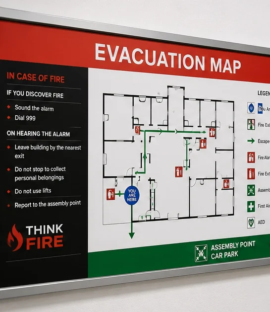

What Our Evacuation Maps Include
Each map is tailored to your building layout and operational requirements. Depending on your premises, your evacuation map may include:
- Main escape routes
- Alternative escape routes
- Fire exits
- Fire alarm call points
- Fire extinguishers
- First aid points
- AED locations
- Assembly points
- Restricted or high-risk areas
- Accessible evacuation routes
- “You Are Here” markers
Our designs are clear, practical, and easy to understand at a glance.
Suitable for a Range of Premises
Think Fire can create Emergency Evacuation Maps for:
- Offices
- Retail premises
- Warehouses
Factories and industrial units - Schools and education settings
- Apartment block communal areas
- Hospitality venues
- Healthcare and care settings
- Community buildings
- Public-facing premises
We Are Ready To Help You
Where Should Evacuation Maps Be Displayed?
Evacuation maps should be placed where people can see them easily, especially in areas where occupants may need quick guidance.
Common locations include:
- Main entrances and reception areas
- Corridors and escape routes
- Stairwells and lift lobbies
- Notice boards
- Staff rooms
- Communal areas
- Near final exits
Supporting Your Fire Safety Procedures
Emergency Evacuation Maps should work alongside your wider fire safety arrangements, including fire risk assessments, fire drills, staff training, emergency plans, and PEEP or GEEP procedures where required.
They are not a replacement for training, but they are a useful visual tool that helps people understand what to do and where to go during an emergency.
Professional Evacuation Map Design
When you choose Think Fire, you receive a clear, professionally prepared evacuation map designed around your premises.
Our service includes:
- Review of your building layout
- Clear escape route marking
- Fire safety equipment location markers
- Assembly point identification
- Easy-to-read visual design
- Practical advice on map placement
Support with wider fire safety planning
Book Your Emergency Evacuation Map
If your premises needs a clear and professional Emergency Evacuation Map, Think-Fire can help.
Contact Think-Fire today to arrange your evacuation map and improve fire safety awareness across your building.